
In January 2015, Pyramid Geophysical Services conducted a geophysical investigation at an open sinkhole (ground collapse) in a dry retention pond for a client at their remediation site in Tennessee. The survey was conducted to determine the lateral and vertical extent of the sinkhole feature in the subsurface, and to … [Read more...]
Seismic Site Classification

Pyramid Geophysical Services conducted a geophysical investigation across a proposed apartment complex property in Charlotte, NC. This survey was performed to determine average shear wave velocities in the upper 100 feet of the subsurface to provide seismic data to the client for the purposes of determining a seismic … [Read more...]
Ground Penetrating Radar to Map Septic Leach Field Drainlines
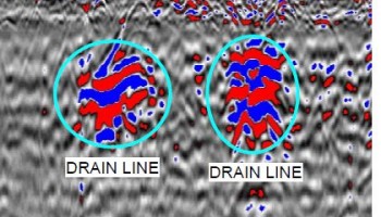
Pyramid Geophysical Services has utilized ground penetrating radar (GPR) to locate and delineate the extents of septic leach fields and septic drain lines at a variety of locations. Typically, these drain field systems are constructed by digging trenches in the ground where perforated drain lines are placed and then … [Read more...]
Landfill Delineation

North Carolina contains hundreds of properties that served as landfill sites in the past; these former landfills have long since been inactive, and many of the sites are overgrown with no specific knowledge of the extent of the buried waste. In North Carolina, the Department of Environmental Quality (DEQ) has … [Read more...]
Seismic Refraction

Pyramid Geophysical Services was contracted to perform seismic refraction survey along a proposed trail in North Carolina. The seismic refraction method consists of measuring (at known points along the surface of the ground) the travel times of compression waves (P-waves) generated by an impulsive energy source. In … [Read more...]
