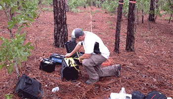
Pyramid utilizes Electrical Resistivity Tomography (ERT) as a surface geophysical tool to provide information to our clients regarding geologic site conditions, hydrogeologic characteristics, and conductivity variability associated with environmental concerns. We utilize the Advanced Geosciences, Inc. (AGI) Supersting … [Read more...]
Seismic Services

Multi-Channel Analysis of Surface Waves (MASW) Pyramid staff have taken advantage of this relatively new technique in the recent past for the purposes of geologic mapping, identifying depth to rock, analyzing subsurface velocity and density profiles, and geotechnical investigations. We utilize the Geometrics Geode … [Read more...]
Geophysical Mapping of a Sinkhole

In January 2015, Pyramid Geophysical Services conducted a geophysical investigation at an open sinkhole (ground collapse) in a dry retention pond for a client at their remediation site in Tennessee. The survey was conducted to determine the lateral and vertical extent of the sinkhole feature in the subsurface, and to … [Read more...]
Geophysical Mapping of Sand Unit Thickness

Pyramid Geophysical Services was contracted to perform an electrical resistivity geophysical mapping survey across 230 acres of undeveloped land in North Carolina. The purpose of the survey was to quantify the lateral extents and approximate depth/thicknesses of sandy soils near the ground surface. The client was … [Read more...]
3D Modeling of Electrical Resistivity Data

Electrical resistivity (ER) testing is an effective geophysical method to identify subsurface geologic hazards, stratigraphic variability, karst features, and hydrogeologic conditions. A typical single ER test utilizes an array of electrodes placed in a straight line at a consistent spacing across a target area. This … [Read more...]
