
Underground Storage Tank (UST) Investigations Using Geophysics
Pyramid Geophysical Services has performed a multitude of Underground Storage Tank (UST) investigations throughout North Carolina using geophysical methods. These metallic USTs are often left behind at old fuel service stations that have closed down. Old home heating oil tanks ...

Seismic (MASW) Surveys to Investigate Top of Rock
One of the most common applications of near-surface seismic testing is to identify the depth of the top of a bedrock unit in the subsurface. The two most effective seismic methods associated with this application are: 1) Seismic refraction, and ...

Slope Stability Analysis Using Geophysics
Pyramid Geophysical Services was contracted to assist in a comprehensive evaluation of subsurface geologic and hydrogeologic conditions along a causeway in South Carolina. The causeway was experiencing slope failures and ground collapses. These failures were thought to be the result ...

Ground Penetrating Radar (GPR) Investigation of Shallow Bedrock
Ground penetrating radar (GPR) is an effective tool to rapidly image shallow bedrock under the right conditions. This project was conducted along a proposed pipeline alignment where geotechnical boring logs showed variable bedrock depth along the entirety of the alignment ...

Geophysical Ground Conductivity Mapping
The use of electromagnetic (EM) geophysical methods to evaluate ground conductivity variations is an effective tool to resolve environmental issues. However, the EM profiling instruments commonly used (such as the Geonics EM31 ground conductivity meter) for such applications provide depth-averaged ...

GPR Investigation of Sub-Slab Voids
Pyramid Geophysical Services conducted a geophysical investigation at a facility in Asheboro, NC where the client had indicated that a water line had leaked/ruptured beneath a concrete slab-on-grade structure. The rupture resulted in visible water penetrating upward through seams in ...

Carlsbad Caverns – Resistivity Mapping for Caves
Pyramid Geophysical Services performed a geophysical investigation for the National Park Service at Carlsbad Caverns National Park in Carlsbad, NM. The survey used electrical resistivity mapping (ER) to look for potential underground caves or caverns near an area designated for ...

Geophysical Investigation to Identify Buried Infrastructure and Waste
Pyramid Geophysical Services conducted a geophysical investigation across a project site that contained buried waste and exhibited the potential to contain buried infrastructure such as former foundations. Our client wanted to delineate the lateral extent and depths of any buried ...
Concrete Inspection Using High Frequency Ground Penetrating Radar
Pyramid Geophysical Services completed a ground penetrating radar (GPR) concrete inspection survey in a municipal parking garage in North Carolina. The purpose of the survey was to locate rebar and post tension cables within the concrete floor slab of one ...
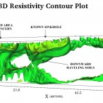
Geophysical Mapping of a Sinkhole
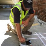
In January 2015, Pyramid Geophysical Services conducted a geophysical investigation at an open sinkhole (ground collapse) in a dry retention pond for a client at their remediation site in Tennessee. The survey was conducted to determine the lateral and vertical ...

Seismic Site Classification
Pyramid Geophysical Services conducted a geophysical investigation across a proposed apartment complex property in Charlotte, NC. This survey was performed to determine average shear wave velocities in the upper 100 feet of the subsurface to provide seismic data to the ...

Geophysical Mapping of Sand Unit Thickness
Pyramid Geophysical Services was contracted to perform an electrical resistivity geophysical mapping survey across 230 acres of undeveloped land in North Carolina. The purpose of the survey was to quantify the lateral extents and approximate depth/thicknesses of sandy soils near ...

3D Modeling of Electrical Resistivity Data
Electrical resistivity (ER) testing is an effective geophysical method to identify subsurface geologic hazards, stratigraphic variability, karst features, and hydrogeologic conditions. A typical single ER test utilizes an array of electrodes placed in a straight line at a consistent spacing ...

Ground Penetrating Radar to Map Septic Leach Field Drainlines
Pyramid Geophysical Services has utilized ground penetrating radar (GPR) to locate and delineate the extents of septic leach fields and septic drain lines at a variety of locations. Typically, these drain field systems are constructed by digging trenches in the ...

Landfill Delineation
North Carolina contains hundreds of properties that served as landfill sites in the past; these former landfills have long since been inactive, and many of the sites are overgrown with no specific knowledge of the extent of the buried waste ...

Seismic Refraction
Pyramid Geophysical Services was contracted to perform seismic refraction survey along a proposed trail in North Carolina. The seismic refraction method consists of measuring (at known points along the surface of the ground) the travel times of compression waves (P-waves) ...

Oil Field Hazard Characterization
Pyramid Geophysical Services was contracted to perform an electrical resistivity (ER) survey on several current and proposed well drilling sites in Oklahoma. The purpose of the survey was to identify subsurface voids and depth to bedrock at the drilling sites, ...

Electrical Resistivity Mapping Across a Stream Channel
Electrical Resistivity Tomography (ERT) is an effective method for engineering projects in atypical environments that require a detailed understanding of geologic conditions, stratigraphy and/or hazards. ERT is unique among geophysical methods because a single test can be performed crossing both ...

Geophysics Multimedia
To view geophysics multimedia, such as narrated presentations and videos of some of our geophysical investigations, please visit our YouTube Channel! ...

Geophysical Clay Stratum Investigation
Pyramid Geophysical Services was contracted to conduct a near‐surface geophysical investigation in Fayetteville, North Carolina, in an effort to identify the depth and extent of a subsurface clay stratum. The clay unit was of concern to an active chemical plant ...
