Pyramid Geophysical Services

  • Facebook
  • LinkedIn
  • YouTube

(336) 335-3174

  • Home
  • About Us
  • Services
    • Ground Penetrating Radar
    • Electromagnetics
    • Electrical Resistivity
    • Seismic Services
    • Private Utility Locating
  • Applications
    • Underground Storage Tanks
    • Geotechnical Geophysics
    • Private Utility Locating
    • Geologic Hazards
    • Landfill Geophysics
    • Water Resources
    • Geologic Mapping
  • Case Studies
  • FAQ
  • Newsletter Archive
  • Contact
  • Pyramid Environmental

Slope Stability Analysis Using Geophysics

void under road

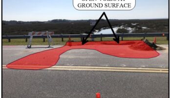
Pyramid Geophysical Services was contracted to assist in a comprehensive evaluation of subsurface geologic and hydrogeologic conditions along a causeway in South Carolina. The causeway was experiencing slope failures and ground collapses. These failures were thought to be the result of both the presence of buried … [Read more...]

Filed Under: Case Studies Tagged With: electrical resistivity, electromagnetic, GPR, ground collapse, MASW, seismic, slope geophysics, slope stability analysis, voids

Geophysical Ground Conductivity Mapping

conductivity map of coal ash

The use of electromagnetic (EM) geophysical methods to evaluate ground conductivity variations is an effective tool to resolve environmental issues. However, the EM profiling instruments commonly used (such as the Geonics EM31 ground conductivity meter) for such applications provide depth-averaged conductivity values … [Read more...]

Filed Under: Case Studies Tagged With: coal ash, conductivity, earth conductivity, electrical resistivity, electromagnetics, EM31, fly ash, geophysics, north carolina geophysics, resistivity

Carlsbad Caverns – Resistivity Mapping for Caves

2D and 3D Cave Mapping with Resistivity

Pyramid Geophysical Services performed a geophysical investigation for the National Park Service at Carlsbad Caverns National Park in Carlsbad, NM. The survey used electrical resistivity mapping (ER) to look for potential underground caves or caverns near an area designated for the construction of an underground … [Read more...]

Filed Under: Case Studies Tagged With: electrical resistivity, karst geophysics, north carolina geophysics, void mapping

3D Modeling of Electrical Resistivity Data

Electrical resistivity (ER) testing is an effective geophysical method to identify subsurface geologic hazards, stratigraphic variability, karst features, and hydrogeologic conditions. A typical single ER test utilizes an array of electrodes placed in a straight line at a consistent spacing across a target area. This … [Read more...]

Filed Under: Case Studies Tagged With: 3D resistivity, electrical resistivity, ERT, karst, MER, sinkhole, three dimensional resistivity

Electrical Resistivity Mapping Across a Stream Channel

Resistivity Across Stream Channel

  Electrical Resistivity Tomography (ERT) is an effective method for engineering projects in atypical environments that require a detailed understanding of geologic conditions, stratigraphy and/or hazards. ERT is unique among geophysical methods because a single test can be performed crossing both land and … [Read more...]

Filed Under: Case Studies Tagged With: bridge replacement, electrical resistivity, ERT, marine resistivity, MER

Certifications and Affiliations

GSA Contract

#gsa #contract

AFFILIATED COMPANIES

LPT Systems

Provider of lubrication, pump and tank systems and equipment, sales and service

Pyramid Environmental Services

Pyramid Environmental is our Parent Company

© Pyramid Geophysical Services Inc., a subsidiary of Pyramid Environmental & Engineering, P.C.
503 Industrial Avenue, Greensboro, NC 27406

| site by jbQ Media Web & SEO |