
Understanding the geology at specific project sites can be essential for a wide variety of applications, including construction design, water supply investigations, environmental concerns, and general site stability. Geophysical tools allow for a rapid characterization of site geology that, when correlated to borings … [Read more...]
Geophysical Mapping of Sand Unit Thickness

Pyramid Geophysical Services was contracted to perform an electrical resistivity geophysical mapping survey across 230 acres of undeveloped land in North Carolina. The purpose of the survey was to quantify the lateral extents and approximate depth/thicknesses of sandy soils near the ground surface. The client was … [Read more...]
Geophysical Clay Stratum Investigation
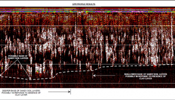
Pyramid Geophysical Services was contracted to conduct a near‐surface geophysical investigation in Fayetteville, North Carolina, in an effort to identify the depth and extent of a subsurface clay stratum. The clay unit was of concern to an active chemical plant located at the site. Due to the potentially thin nature … [Read more...]
